Understanding ARR Site Eligibility: How Treeconomy’s New Assessment Works
Discover the key factors determining ARR site eligibility and learn how Treeconomy’s new assessment streamlines the evaluation process.
Product Updates
Science & Tech
Project Development
Carbon Credits
Company News
Aug 15, 2024
Carolina Amu Trujillo

Developing nature-based carbon projects, particularly Afforestation, Reforestation, and Revegetation (ARR) initiatives, is crucial to addressing the nature funding gap and advancing toward Net Zero. However, the development of these projects, from project inception to the issuance of carbon credits, is lengthy, with the development of a carbon offset project typically taking 12 to 36 months. Forestry projects take even longer, averaging 24 to 36 months to issue their first credits. The primary reason for this long timeline is the complex and time-consuming task of collecting and analysing data to make informed decisions about project feasibility and implementation.
Understanding land eligibility and the potential options for ARR interventions is a critical first step in developing a nature-based carbon project. Traditionally, this has been a complex process, requiring fieldwork, data collection, and analysis, all contributing to the overall delay in getting projects off the ground.
Treeconomy’s New Project Site Eligibility Assessment Launch
To address this challenge, last Tuesday, we launched our new Project Site Eligibility Assessment (learn more about it here). Rapid and accessible, it isolates areas eligible for Afforestation, Reforestation, and Revegetation (ARR) in accordance with carbon standards. This assessment expedites the initial stages of project development, allowing project developers to make decisions quickly and confidently, backed by reliable scientific data.
In this blog, we will provide an overview of the eligibility criteria for ARR projects and explain how our new Project Site Eligibility Assessment works.
Eligibility Criteria: What Makes Land Suitable for ARR?
For an area to be eligible for ARR intervention, it must not currently be classified as a healthy forest. This includes areas that have been deforested or degraded ten or more years prior, as well as areas that are not and have never been covered by forest. These criteria align with the most popular ARR standards currently in the carbon market, specifically Verra VM0047 and Gold Standard.
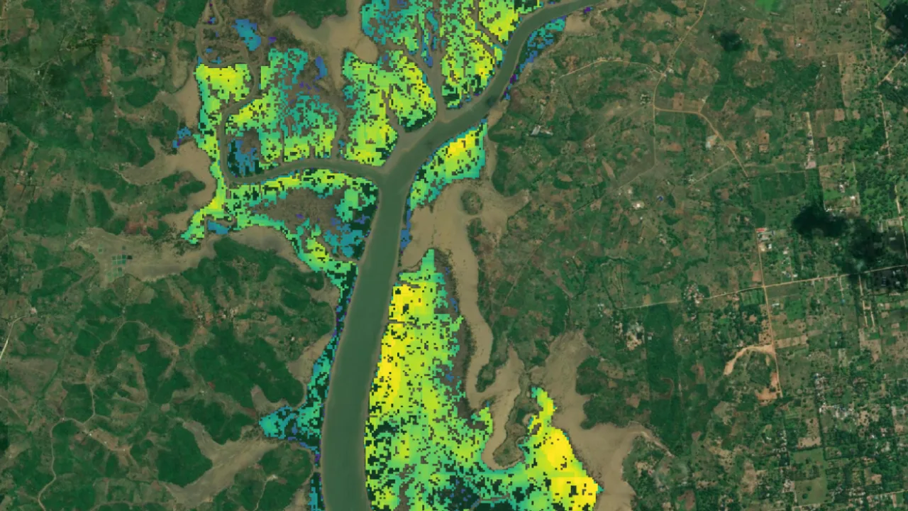
Our Project Site Eligibility Assessment results in a detailed map showing areas eligible for ARR interventions and the total number of eligible hectares obtained by collecting and conducting a thorough data analysis of large areas within and around the area of interest. The map serves as a critical starting point for project developers, enabling them to quickly identify viable project sites and begin planning.
How Does the Assessment Work?
The assessment leverages and cross-references multiple satellite data sets to ensure a comprehensive and accurate result.
- Borders and Boundaries: The assessment checks that the potential project area does not overlap with any national park.
- Land Use Land Cover (LULC) Change Analysis: Following the Dynamic World Land Use Land Cover dataset, the land is categorised into nine distinct land-use categories. The assessment examines the changes in these categories over the past ten years to isolate areas within the project boundary that have not been classified as forests in the past decade. Additionally, we investigate areas where activities have led to forest loss within the last decade.
- Multispectral analysis: Using forestry-specific metrics derived from multispectral satellite imagery, we further classify the intactness of forests over at least the last ten years. This analysis can highlight small-scale deforestation, such as thinning and selective logging, that other analyses will miss.
- Forest Intactness Evaluation: The assessment cross-references the Land Use Land Cover Change Analysis and Multispectral Analysis results by evaluating the state of forests within the project boundary. Forests are classified into three categories: intact forest, degraded forest, and deforested. This classification provides a detailed understanding of the forest’s current state and its changes over the past 10 years.
Data and analysis to support the results are provided, future-proofing against changes in standards or future allegations.
Assurance and Speed for ARR Project Development
Treeconomy’s Project Site Eligibility Assessment is a game-changer for developing pre-development carbon projects. Providing rapid and reliable data enables developers to start having constructive and informed discussions in planning and stakeholder engagement much earlier in the project process, paving the way for more efficient and successful project implementation. Comprehensive data and analysis also ensure that project developers are future-proofing their projects, ensuring that their projects meet evolving carbon standards and regulatory requirements.
This assessment plays a crucial role in accelerating and scaling the development of ARR projects by streamlining one of the most time-consuming steps at the start of project development.
Assess Your Project With Treeconomy
Download our brochure if you have questions about our new Project Site Eligibility Assessment. You can also contact our team at hello@treeconomy.co.
If you're ready to request your assessment and are already a Sherwood platform user, sign in here to request it directly. If you need a Sherwood account, please submit your information using the interest form.